HURSTBOURNE – I have a special place in my heart for the neighborhood of Hurstbourne. It has been my home for over 15 years. It is the place where I raised my children, enjoyed all the amenities at the premier Hurstbourne Country Club, and where I made some of my best friends. It’s no wonder Hurstbourne is such a desirable neighborhood where homes are in high demand. The rich history of Hurstbourne dates back to post-revolutionary war times.
Definition of “Hurstbourne”
Hurstbourne is a wedding of two words; ‘hurst’, meaning a grove of trees, a copse, or a woods, and ‘bourne meaning boundary. The individual who in the 19th Century first gave this beautiful name to the property is not known.
Beargrass Creek “Stations”
The history of Hurstbourne is a history of Kentucky and a young nation’s growth. The development of “stations” or stockades along Beargrass Creek, in the late 18th Century, signaled the arrival of white man’s civilization and the beginning of the nation’s westward expansion.
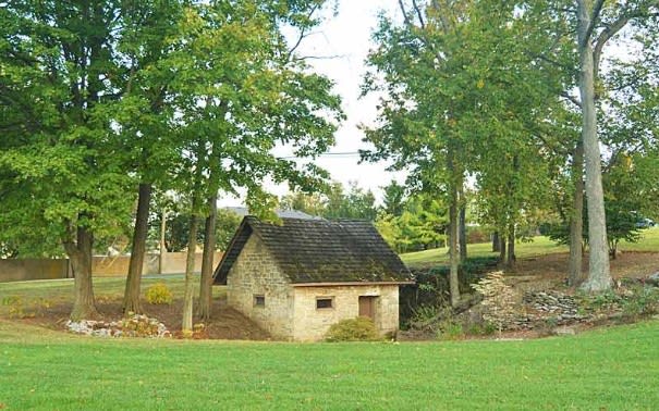
Spring House
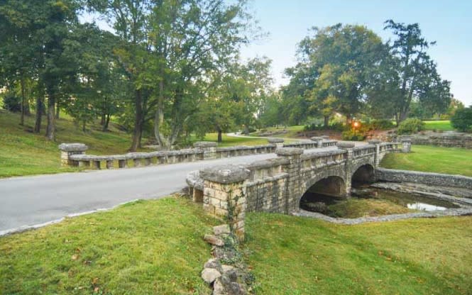
Beagrass Creek Bridge
It is probable that the first of these “stations” was one established by William Linn in 1779. He settled on a tract he may have selected in 1776 when he was a leader of an expedition down the Ohio and Mississippi Rivers. The location he chose is well known today as it is the scenic site of Hurstbourne Country Club.
The natural beauty of the site may have been the least of Linn’s criteria. He was interested in the fertility of the land and the large spring which poured its waters into Beargrass Creek. The spring still flows and the ancient stone spring house stands today beside the tenth tee of Hurstbourne’s Championship Golf Course. There are also two old stone dwellings east of Hurstbourne’s Club House that date from the later days of the 1780’s.
Linn was one of the 39 signers of the 1779 petition to the Virginia Legislature to establish the Town of Louisville, named for King Louis XVI. The charter was granted in 1780. Linn received a Virginia land grant for 400 acres early in 1780 “to include the place where the Linn’s now live.”
A law adopted by the Virginia Legislature in 1779 provided for the sale of land in Kentucky at only $9 for 400 acres after which a rush of settlers began. The proprietors of stations were the first to benefit from the rush, the stations serving as the motels and supermarkets of the day, as well as providing defense against marauding Indians.
Prospective settlers rented cabins in the stations while they sought land of their own and purchased powder, shot and other supplies from the merchant-proprietors. The stations also provided a reservoir of men and supplies for expeditions against the Indians. Linn himself joined George Rogers Clark on an expedition from the Falls into Ohio in 1780 to pursue Indians who had been harassing settlements in the Bluegrass area.
Linn looked forward to years of increasing prosperity in this new western country but his hopes were brought to a sudden and violent end. On March 5, 1781, he set out for Louisville the town he had helped found, to attend the first meeting of the new Jefferson County Court.
Bland Ballard, living at Linn’s Station recovering from a wound received during Clark’s 1780 Ohio Campaign, later recalled the tragedy: “Linn left the station a little ahead of the others of the party who were going to the court. Shortly after, reports of several guns were heard. A party from the fort immediately went to the place and found his horse killed by a shot, but could not find nothing of Linn. The next day the search was renewed, and his body was found about a mile from the station and near the present place of residence of Colonel Anderson.”
The grave site of William Linn is unmarked and unknown but his name has not entirely vanished. Area historians agree that nearby Lyndon probably derives its name from Major Linn and his pioneer station.
After Linn’s death, his heirs discovered his title to the land was faulty. Though Linn had received a Virginia grant, a prior grant had been given for the same land to a veteran of the French and Indian Wars.
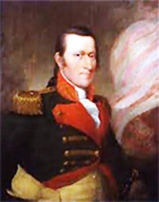
Richard Clough Anderson
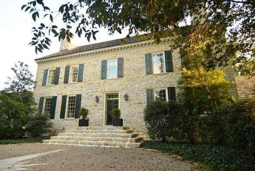
Soldiers Retreat (Restored)
The history of the land continues with two early deeds recorded in Jefferson County Deed Books I and II. The first, dated October 1, 1786, and recorded June 2,1789, was from Henry and Mary Harrison of Surrey County, Virginia, to Peyton Short of Lincoln County, Kentucky, for “1000 acres by survey of June 7, 1774 on Beargrass Creek about five miles from the Ohio River.” The second deed dated April 5, 1789, was from Peyton Short of Surrey County, Virginia, to Richard Clough Anderson for” five hundred acres, being part of an old military survey patented and in the name of Henry Harrison”, and “being in Jefferson County on the head of Beargrass commonly called Linn’s Station.”
Richard Clough Anderson, named in the second deed, was one of Louisville’s earliest historical figures. He was born in Hanover County, Virginia, in 1750; was a member of the Virginia Continental Line; was wounded at Trenton and Savannah; taken prisoner at Charleston; acted as aide-de-camp to Lafayette and to General Nelson at Yorktown; and retired as a It. Colonel. In 1783 he was appointed principal surveyor for all Virginia military boundary lines and in 1784 moved to Kentucky. In 1787 he married Elizabeth, the sister of George Rogers Clark.
On the land he purchased from Peyton Short he built a stone mansion house which he called Soldier’s Retreat, where he lived until his death in 1826. The old house has been gone for over a hundred years but several of the stone out-buildings and the family burying ground, remain.
The center section of the present Club House of Hurstbourne Country Club was on Col. Anderson’s estate, and is thought to have been built about 1818. For whom it was built is not known. Several families owned it before it was deeded on July 6, 1915 by Elizabeth A. F. Harris, widow of Joseph L. Harris, to Alvin T. Hert. The land in that deed was described as “Hurstbourne Farm in Jefferson County, Kentucky on Shelbyville Turnpike and waters of Beargrass.” Several Louisvillians remember the house when the Harris’s lived in it and described it as very English, almost Tudor in decoration, and recollect that the living room was filled with silver trophies.
Mr. and Mrs. Alvin T. Hert were prominent in Louisville Social and political affairs. Mrs. Hert was Vice-Chairman of the Republican National Committee from 1924 to 1936, and Mr. Hert, head of the American Creosoting Company, was also prominent in Republican politics until his death in 1921.
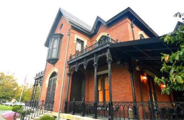
Old Lyndon Hall
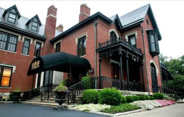
Part of Hurstbourne CC Main Club House
In 1928, Mrs. Hert engaged E. T. Hutchings, a Louisville architect, to remodel and enlarge the house for her residence. Her original plan was to give the appearance of the old 1918 brick center to wings which were to be added, but she liked the color of the new brick so well that the outside layer of the old brick from the center portion was removed and the whole house covered with the new. The Gothic details, added to the old brick house, possibly by the Harris’s, were retained and carried out on the exterior of the mansion.
The most beautiful room in the house was the 60′ x 30′ drawing room with its 14′ ceiling, now the main dining room of the Hurstbourne County Club. Mrs. Hert engaged Charles Duveen, head of the noted decorating and antiques firm of Charles of London, in New York, to panel the room for her with oak paneling from a century old English house, and the ornamental ceiling was designed from a pattern taken from the same house. H. Charles Duveen was one of the twelve children of Sir Joel Duveen, founder of the famous firm of Duveen Brothers in London, and was a brother of Lord Joseph Duveen, noted art connoisseur and dealer. It was Charles of London who introduced the vogues for Elizabethan period furnishings in America, and decorated many palatial homes in the United States. A year or so before he brought the paneling to Hurstbourne, he imported a paneled room once used by Charles I for William Randolph Hearst at a cost of $150,000.
There were 35 rooms in Lyndon Hall, now the Hurstbourne Club House, counting the storage rooms, vaults, cold rooms, machinery rooms and many baths. One of the garages behind the Club House was once a stable that was the home of the famous race horse, Ten Broeck, named for a family that occupied the house at one time. Mrs. Hert’s saddle horse, Major Pendennis, and a German police dog are buried in marked graves on the estate. The beautiful, white frame house beside the Clubhouse belongs to the Charles McNeal family, relatives of Mrs. Hert. For about twenty years, until her death in 1948, Mrs. Hert lived in her lovely home with its beautiful gardens complete with a gazebo and gorgeous strutting peacocks.
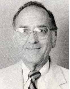
L LeRoy Highbaugh Jr

1966 Aerial Photo of Hurstbourne

City of Hurstbourne – Present Day
The estate was purchased in 1949 by L. LeRoy Highbaugh Sr. and Jr. and the name changed to Highbaugh Farms. The Highbaughs lived in the house for a number of years. In 1965, Highbaugh began to develop the estate into a community to be known as Hurstbourne. The community was planned to have a shopping center, offices, schools, churches, a country club complex containing a 27 hole golf course covering 240 acres, and stately Lyndon Hall as its club house. The streams, creek beds, well planned plantings and other natural features, as well as the site of Linn’s Station, its springhouse, the Anderson graveyard and old stone out-buildings, have been thoughtfully preserved and carefully incorporated into the long range planning for Hurstbourne at the request of L. Leroy Highbaugh, Jr.
The aura of a long and rich history still permeates throughout Hurstbourne. This history unfolds into an over two hundred year panorama of Kentucky life beginning with the its early settlers, forward to a contemporary builder, and on to the establishment of a first class City – all conveniently nestled in eastern Jefferson County.
Hurstbourne Incorporated as a City in 1982
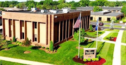
City of Hurstbourne City Hall Building
4,669 people live in Hurstbourne, where the median age is 37.8 and the average individual income is $61,252. Data provided by the U.S. Census Bureau.
Total Population
Median Age
Population Density Population Density This is the number of people per square mile in a neighborhood.
Average individual Income
There's plenty to do around Hurstbourne, including shopping, dining, nightlife, parks, and more. Data provided by Walk Score and Yelp.
Explore popular things to do in the area, including Prepping With Peppers, Fitness Integrated Science, and Freestyle Fitness.
| Name | Category | Distance | Reviews |
Ratings by
Yelp
|
|---|---|---|---|---|
| Dining | 3.22 miles | 5 reviews | 5/5 stars | |
| Active | 4.67 miles | 5 reviews | 5/5 stars | |
| Active | 1.71 miles | 7 reviews | 5/5 stars | |
| Active | 1.92 miles | 18 reviews | 5/5 stars | |
| Active | 2.44 miles | 5 reviews | 5/5 stars | |
| Active | 2.39 miles | 5 reviews | 5/5 stars | |
| Active | 4.23 miles | 7 reviews | 5/5 stars | |
| Beauty | 2.91 miles | 13 reviews | 5/5 stars | |
| Beauty | 3.89 miles | 16 reviews | 5/5 stars | |
| Beauty | 0.93 miles | 7 reviews | 5/5 stars | |
| Beauty | 1.04 miles | 11 reviews | 5/5 stars | |
| Beauty | 2.03 miles | 5 reviews | 5/5 stars | |
| Beauty | 2.25 miles | 8 reviews | 5/5 stars | |
| Beauty | 1.61 miles | 8 reviews | 5/5 stars | |
| Beauty | 3.32 miles | 5 reviews | 5/5 stars | |
|
|
||||
|
|
||||
|
|
||||
|
|
||||
|
|
||||
|
|
Hurstbourne has 1,836 households, with an average household size of 2.54. Data provided by the U.S. Census Bureau. Here’s what the people living in Hurstbourne do for work — and how long it takes them to get there. Data provided by the U.S. Census Bureau. 4,669 people call Hurstbourne home. The population density is 2,593.17 and the largest age group is Data provided by the U.S. Census Bureau.
Total Population
Population Density Population Density This is the number of people per square mile in a neighborhood.
Median Age
Men vs Women
Population by Age Group
0-9 Years
10-17 Years
18-24 Years
25-64 Years
65-74 Years
75+ Years
Education Level
Total Households
Average Household Size
Average individual Income
Households with Children
With Children:
Without Children:
Marital Status
Blue vs White Collar Workers
Blue Collar:
White Collar:
Get assistance in determining current property value, crafting a competitive offer, writing and negotiating a contract, and much more. Contact me today.